
Subsurface Data Management and Reporting Software
gINT can help you report and manage subsurface data in almost any way with custom reports including graphics, photos, charts, maps, and more. The software helps you manage borehole, well logs, CPT, and geophysical logs. You can also create fence diagrams, graphs, tables, and any other imaginable report. This capability is available within multiple applications to suit your requirements:
- gINT Logs offers high-end boring and well log data management and reporting.
- gINT Professional builds on the data management and reporting capabilities of gINT Logs and allows you to use the same data to create fence diagrams, graphs, tables, and virtually any other imaginable report.
- gINT Professional Plus takes gINT to the next level with SQL Server support for efficient, centralised data management, and powerful multi-project reporting.
- gINT Collector enables efficient mobile data collection.
gINT Logs

gINT Logs can include virtually any type of subsurface – environmental, geophysical, petroleum, mining, and more. Using gINT logs, you can report and manage bore holes and well log data.
- Quickly enter or import data
- Print or export log reports
- Include virtually any type of subsurface – environmental, geophysical, petroleum, mining, and more
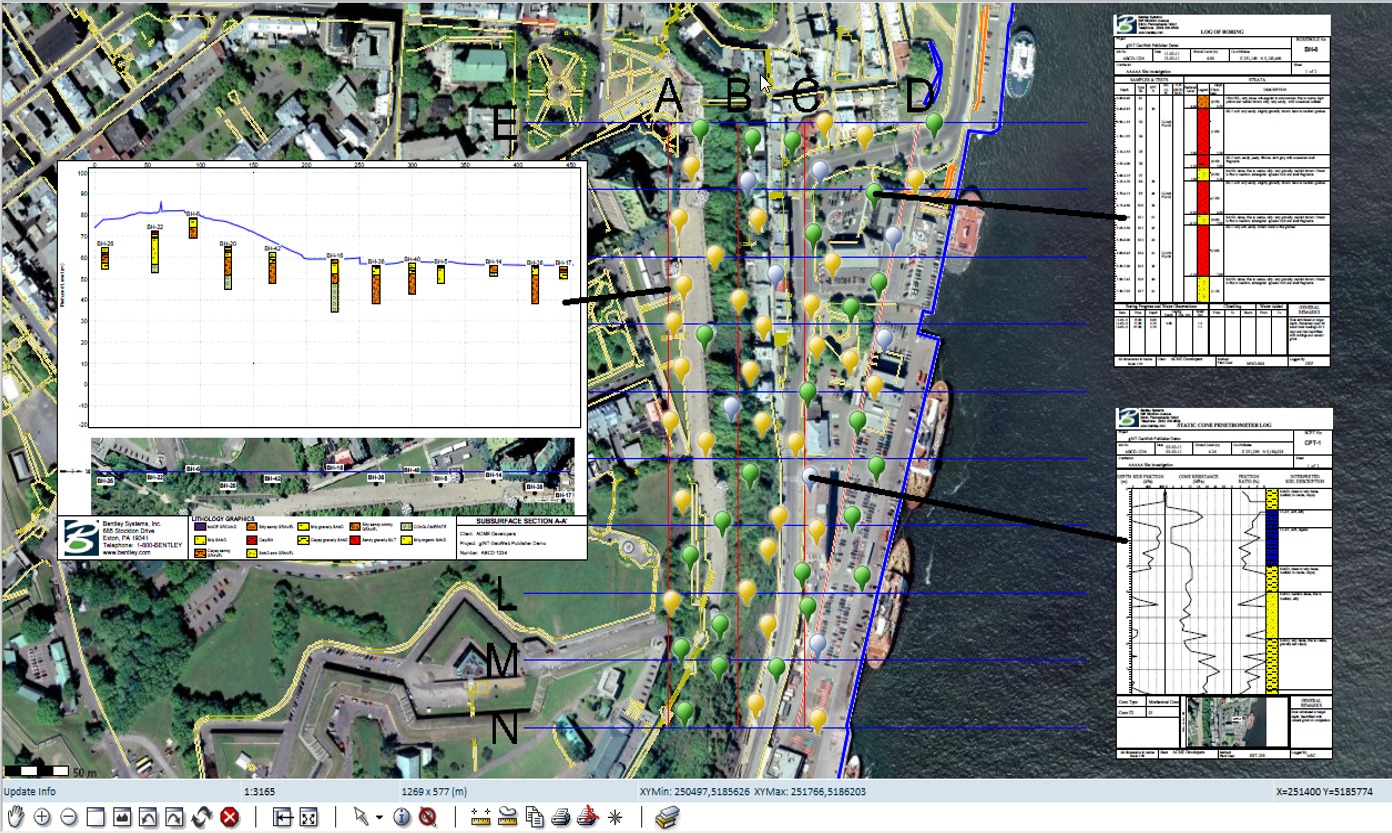
Create and visualize geotechnical reports
Virtually create any type of subsurface report – including borehole and well logs, fence diagrams, cross sections/profiles, site maps, graphs, and tables – all from the same data. Standardize reports with advanced report design tools for conditional formatting, data manipulation, and decision making.
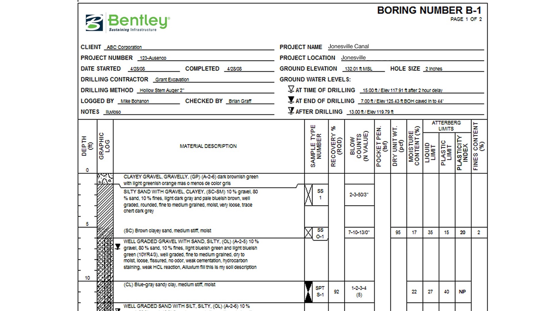
Create geotechnical borehole logs
Jump-start with log reports provided with gINT installation, or design log reports to match your organization’s conventional paper logs. Add intelligence and data-sensitivity to your log reports with a rich set of log report properties and embedded expressions.
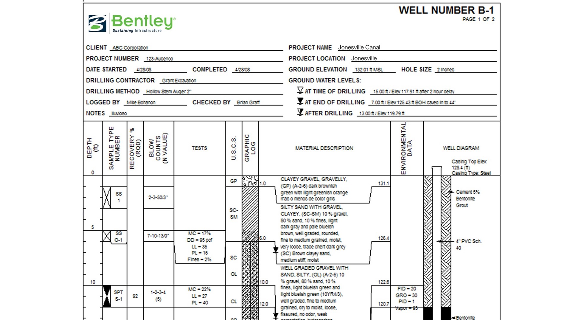
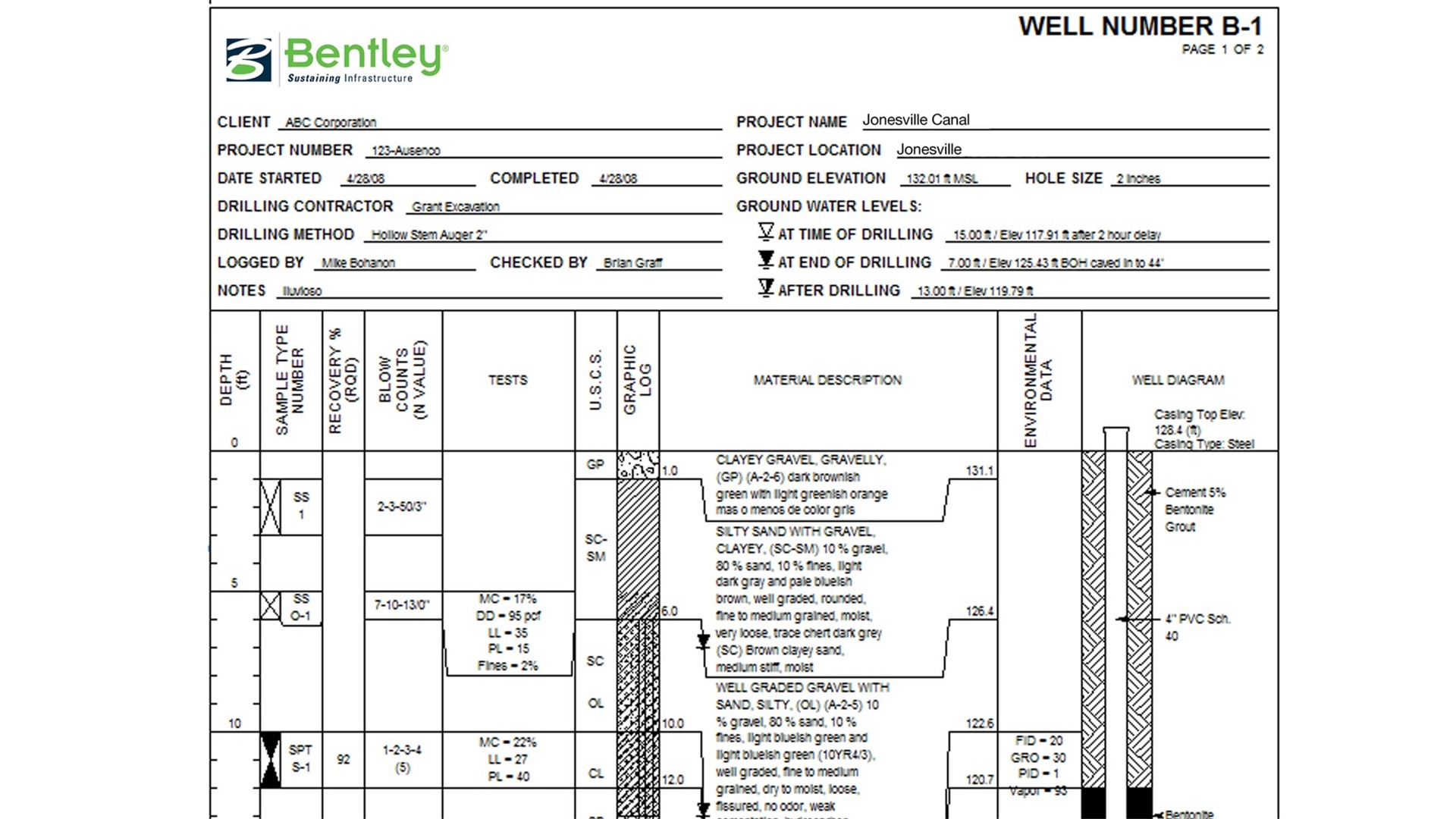
Create geotechnical well logs
Customise your well logs with ease. Plot basic wells and complex well lithology diagrams, lab and field tests, geological information, or any other required data. Create smart reports that display columns when specified data is available.
Interoperate with engineering applications
Save data in a non-proprietary format readily available for reuse by subsurface data consumers such as civil engineers, structural/bridge engineers, and geotechnical engineers for their designs. Import and export data via customary formats such as Excel, CSV, Microsoft Access, AGS, LandXML.
Manage subsurface data
Use subsurface data management tools for data acquisition, validation, queries, reporting, and data sharing among stakeholders on a project level. Geotechnical, geoenvironmental, geology, and mining professionals can use subsurface data via a user-friendly interface.
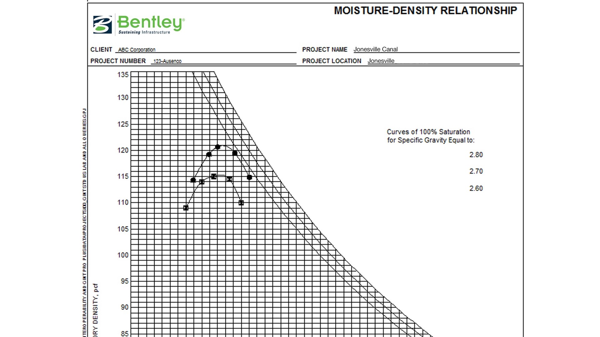
Prepare customised lab testing reports
Expand your report library to comprise nine types of reports: Logs, Fences/Profiles, Graphs, Histograms, Graphic Tables, Text Tables, Graphic Text Docs, Text Docs and Site Maps. You can also design your own, including both field and lab variety reports.
gINT Professional/Plus

gINT Professional enables you to report and manage subsurface data with custom reports including graphics, photos, charts and maps.
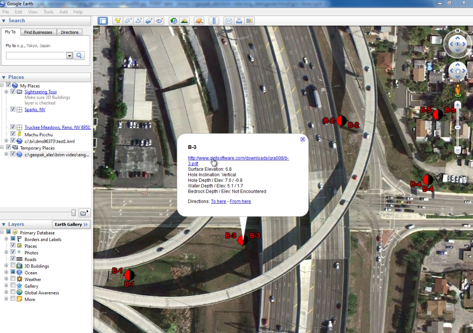
- View subsurface data from Google Earth
- Publish data in Web-based GIS
- Visualize subsurface data in ArcGIS
- Import/Export gINT reports into design, modeling, and analysis software such as Bentley’s civil applications or AutoCAD
gINT Professional Plus enables you to create custom subsurface data reports and adds Microsoft SQL Server support for efficient, centralized data management and powerful multi-project reporting.
- Report and query subsurface data from an unlimited number of projects
- Standardize methods for entering, importing, storing, and reporting data
- Share data with related software programs (including CAD, GIS, and contouring and modeling applications)
- Visualize gINT data using gINT for ArcGIS
- Convert projects so that all use the same geo-coordinate system
Create and visualise geotechnical reports
Virtually create any type of subsurface report – including borehole and well logs, fence diagrams, cross sections/profiles, site maps, graphs, and tables – all from the same data. Standardize reports with advanced report design tools for conditional formatting, data manipulation, and decision making.
Create fence diagrams
Display data from various boring logs in a single report with 2D/3D fence diagrams. Use smart fence diagrams to adjust to the presence or absence of data. Extract surface data, convert to a grid and then display on fence diagrams. Depict features in elevation on your fence report with graphics.
Create geotechnical borehole logs
Jump-start with log reports provided with gINT installation, or design log reports to match your organization’s conventional paper logs. Add intelligence and data-sensitivity to your log reports with a rich set of log report properties and embedded expressions.
Create geotechnical well logs
Customize your well logs with ease. Plot basic wells and complex well lithology diagrams, lab and field tests, geological information, or any other required data. Create smart reports that display columns when specified data is available.
Create multi-project reports
Report and query subsurface data from an unlimited number of projects with Microsoft SQL Server support. Standardize company methods for entering, importing, storing, and reporting data for consistency throughout projects. Convert projects so that they all use the same geo-coordinate system.
Interoperate with engineering applications
Save data in a non-proprietary format readily available for reuse by subsurface data consumers such as civil engineers, structural/bridge engineers, and geotechnical engineers for their designs. Import and export data via customary formats such as Excel, CSV, Microsoft Access, AGS, LandXML.
Manage subsurface data
Use subsurface data management tools for data acquisition, validation, queries, reporting, and data sharing among stakeholders on a project level. Geotechnical, geoenvironmental, geology, and mining professionals can use subsurface data via a user-friendly interface.
Manage subsurface data on multiple projects
Centralize multiple projects in an enterprise database to support global collaboration. Use subsurface data management tools for data acquisition, validation, queries, reporting, and data sharing among stakeholders. Perform coordinate conversion between various coordinate systems
Work with geotechnical subsurface data in 3D
Display gINT subsurface data in 3D, boreholes, lithology, water level, and more. Load data directly from gINT projects and display using different color themes. Combine subsurface data with existing ground survey for comprehensive analysis.
gINT Collector
Site investigation is a crucial step for any engineering project. Low data reusability, errors in multiple entry points, and time delays in inputs cause frustration and additional costs.
With gINT Collector, your geotechnical field data can be collected once on-site using your organization data models in a mobile application. This streamlined process is more accessible and provides an improved data solution for trusted information anytime, anyplace, in your own way.
Advanced data synchronization
Field crews can collect data digitally on-site. Data can then be transferred to the office in minutes or synchronized once connected.
Collect consistent and complete data
Load lookup values from your gINT Library File to ensure descriptions use standardized terminology. Required fields and other options ensure that all necessary data is collected in a usable format. This not only improves the quality of data, but also reduces the log revision process.
Easily import data into your gINT project
Data collection forms are linked directly to your gINT data template (database structure) so no data conversion or complicated data mapping is required. Data can be easily imported into a gINT Project File (GPJ) or SQL Server database
Enter data one time, in the field
Eliminate the time-consuming and error-prone process of transcribing pen-and-paper field logs
Field to office
Data collected in the field can be synchronized to the cloud and loaded into gINT any time. This enables more-informed decision making and adjustments to the field program while the crew is still on-site, as well as accelerates turn-around time for logs and preliminary analysis.
Integration with multidisciplines and project objectives
Create re-usable forms that are suited to different types of projects, ground conditions, field personnel, or other requirements. Whether geo-environmental, hydrogeology, geological, or geotechnical, you can customize the data collection interface to meet your needs.
Keep up with the pace of drilling
Optimize the interface for rapid data collection by utilizing radio buttons, check boxes, lookup lists, and other options, as well as leverage handwriting recognition and voice-to-text technology.
Multi user application
gINT Collector is a multi-user application which enables multiple field crews to work in parallel on the same project. Field crews can reference other boreholes from the app to better understand site conditions while work is underway.
Simple customizable interface
gINT Collector comes with a dedicated feature for building the data collection interface. Forms can be built in minutes with gINT Administrator.
gINT Subscriptions: Low Cost, Zero Hassle
Pair annual practitioner-named subscription licenses with expert services to ensure you are getting the most value from your software investment.
Affordable Lower Upfront Costs: plus access to expert training ensures a faster return on investment.
Accelerated Workflows: Boost design, analysis, and modeling skills team-wide while reducing rework.
Training Tailored to Individual Needs: Choose from customized instruction to on-demand learning and mentoring.
Each subscription license includes a number of Virtuosity Keys or tokens which can be used to help pay for the expert services and training you need to take your project to the next level.
Keys provide add-on value to subscribers with exclusive rights to the tailored training materials built specifically to help you work more efficiently. Choose from tailor-made training, on-demand learning, and mentoring services to build the support program needed for your engineers and designers. Expert services will help improve your design, analysis, and modeling skills to help increase productivity and reduce time away from project work.
The number of Keys received with each subscription varies based on the software purchased, while further Keys can be purchased separately.
Resources
Unleash the power of precision tunnel and underground excavation modeling with PLAXIS | E-Book
Read more
Brochure: Bentley’s Geotechnical Engineering Applications – Digital Workflows eBook
Read more
Can gINT Help Your Upcoming Geotechnical Projects?
Please get in touch for more information, request a free trial or to buy a license.
Simply complete the form opposite or contact us using the details below and we will be in touch as soon as possible.
Alternatively, if you would like to buy online straightaway, simply visit our gINT Online Store now.